Enhancing the Fire Dynamics Simulator for Modeling Wildland Urban Interface
Fires
The Coeur d’Alene Tribe Information Technology – Geographic Information System
(GIS) Program received an initial three year grant, which was extended until
March 2013 from the
United States Department of Commerce National Institute of Standards and
Technology (NIST)
to enhance the Fire Dynamics Simulator (FDS) developed by the
Building and Fire Research Laboratory
division of NIST. The
FDS
is a computation fluid dynamics model of fire-driven flow designed to
synthesize fire behavior, heat transfer, and smoke dispersion in a
3-Dimension simulation. This model has traditionally been used to
simulate structural fires, and developers of this model want to apply it to the
Wildland Urban Interface (WUI). This project has several aspects and
includes:
• providing the FDS modeling program with modeled and surveyed data
gathered, acquired, or derived by the Coeur d’Alene Tribe GIS program;
• identification of a parsimonious data set that contains the minimum data
inputs to run FDS in the WUI;
• development of an Environmental System Research Institute (ESRI)
geodatabase schema and populated geodatabase containing inputs necessary to run
FDS;
• developments of applications linking the FDS program to the ESRI GIS
platform;
• collection of ground data for verification and model input;
• testing the differences in FDS outputs between modeled and surveyed
data;
• testing the applicability of running FDS over large areas and;
• some level of model validation.
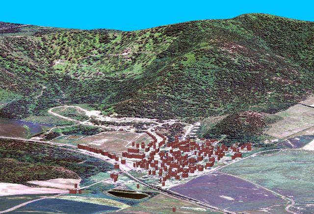
The Coeur d’Alene Tribe collaborated with the FDS group to determine the minimum
necessary inputs to run FDS in the WUI. The modeled data was derivations of
Light Detection and Ranging (LiDAR)
data along with high-resolution multispectral
imagery. The combination of this data allowed for the
creation of the following model inputs:
• Building construction material;
• Proximity and type of combustibles to structures;
• damage to wildland and residential vegetation;
• Road and other fire barrier surfaces;
• Topographical features;
• Vegetation type.
Initially, surveyed data was derived from previous data gathering efforts conducted
by the Coeur d’Alene Tribe. The existing surveyed data consists of surveys
on structures conducted during 2002 and 2003 within the reservation boundary and
Benewah County, collection of vegetation and forest fuels in 2004 and 2005, and
ongoing development of spatial databases of roads, railroads, and other man-made
features. The structure surveys followed National Fire Protection Agency
protocols detailed in form 1144. The vegetation
surveys followed FIREMON protocols
(http:/fire.org/firemone/sampmeth.htm). New surveys conducted as part of this
grant resulted in detailed spatial databases of the inputs necessary to run FDS
as well as providing ground-truthed data for the modeled results. A schema
was developed for an ESRI geodatabase that will serve as the standard for containing
data inputs necessary to run FDS from a GIS environment, and both the modeled and
surveyed data is stored in an ESRI geodatabase that follows this developed
schema. The combination of all of the above data allows for testing
the differences between FDS outputs from modeled data and surveyed
data. This helps determine the necessary level of data collection to
run FDS and the practicality of utilizing FDS as a land management tool.
The linkage of the FDS to a GIS facilitates the creation and storage of FDS
input files from GIS datasets as well as transfer of outputs of FDS to an ESRI
geodatabase. The creation and storage of many FDS input datasets will
occur in a GIS making it logical to develop applications to allow for creation
of FDS input files within a GIS. GIS also provides a mechanism to analyze
and display spatial data. Consequently, the development of applications
that allows for viewing and further analysis of FDS outputs in a GIS environment
will prove useful. The ESRI GIS platform will be used as the software to
run these developed applications. The ESRI GIS platform while being the
software used by the Coeur d’Alene Tribe is also the GIS platform used by most
federal, state, and local government agencies that would ultimately be using
the enhanced FDS model.
The Coeur d'Alene Tribe IT/GIS department continues to support NIST Fire
Safety Research through additional GIS geodatabase management and post-
fire analysis of fires in California and Texas. The overal objectives
address technical factors responsible for destroying, damaging or successful
performance of structures resulting from a fire. Additionally, the
information can be used to recommend improvements to fire regulations and codes
based on its findings.
To view more information on this project please download the powerpoint slides
by clicking
here.
To view the report from the first three years of the project please click
here.