|
The Coeur d'Alene Tribe has been using Geographic Information System (GIS) to
spatially depict their territories located in Idaho. For the past decade, GIS
has served the Tribe in traditional functions of community and land management.
However, recently the Tribe's Elders became very excited about their GIS when
it was proposed that it be used as a solution for preserving the Tribe's
cultural heritage.
The Coeur d'Alene Tribe has had an active GIS program since 1992. A GIS is a
computer system for capturing, storing, checking, integrating, manipulating,
analyzing and displaying data related to positions on the Earth's surface.
Typically, a GIS is used for handling various kinds of maps. These might be
represented as several different layers in which each layer holds data about a
particular kind of feature such as the location of cultural sites. Each feature
is linked to a position on the graphical image of a map. At this time, the
Coeur d'Alene Tribe's GIS server contains over 3,000 GIS datasets. Currently,
the Tribe employs five individuals in its GIS program whose talents include
multimedia development, natural resource management, Internet applications
development, and other computer related experience.
For years, the Tribal Elders asked the GIS project staff, "How can we say it's
our land when our sites are labeled with the white man's words?" Moses
Mountain, for instance, is known in the Coeur d'Alene language as
Ch'ets'tene'st and translated "Log-like Rock Cliff". In an effort to preserve
the Tribe's language, the GIS team joined resources with the Tribe's linguist
and began the new GIS Names-Places Project.
But labels alone do not give these locations cultural meaning; it is the Tribe's
historical and ritual relationships to the land that creates connections. The
Names-Places Project is a collaborative undertaking by the Coeur d'Alene Tribal
Elders, the Language Center, and the GIS Program.
|

|
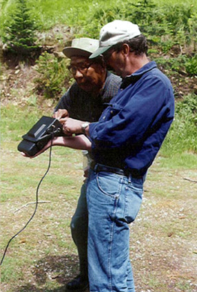
The purpose of the Names-Places Project is to preserve Tribal culture by
visiting geographic sites and recording video, audio, and still photos of
Tribal Elders who describe the site in both English and Coeur d'Alene
languages. Locations of these sites are added to the Tribal GIS. The GIS allows
computer files to be linked to map sites that are accessed with a simple mouse
click. Database information in the forms of digital video, audio, and still
photos of the site are interconnected with the map.
The goal of the Names-Places Project is to link geography, language, and
knowledge of the Coeur d'Alene Tribe aboriginal territory for the preservation
of Tribal Culture. Therefore, the Tribal Elders' knowledge of the aboriginal
territory is priceless. Originally, the Tribe's aboriginal lands stretched
south to Moscow, Idaho, north to Sandpoint, Idaho, west to Spokane, Washington,
and east to St. Regis, Montana spanning more than five million acres. The Tribe
is aware of the need to complete this work before the knowledge slips away with
the passing of the Elders. The Names-Places Project is working diligently to
digitally record, preserve, and store this oral heritage.
The culture of any people is embedded within their language. The growing concern
for language revitalization is unquestionably valid. Because the Tribe's
language expresses the thoughts of Tribal Ancestors' perceptions of the world,
it is the key to understanding the inherent beauty of traditional ways. Thus,
data may be preserved in both English and Coeur d'Alene languages.
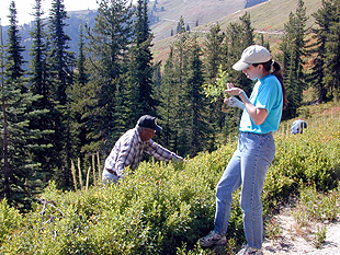
Felix Aripa, one of the few people who still speak the Coeur d'Alene language,
is a Tribal Elder at the heart of the Names-Places project. Even though Felix
is in his eighties, he leads an entourage of college students through the
fields, forests, and mountains of the reservation on data gathering
expeditions. Excited about such spatial tools as GPS for pinpointing important
Tribal sites, Felix is enthusiastic about combining modern technology with
Tribal tradition.
|