GIS Data:
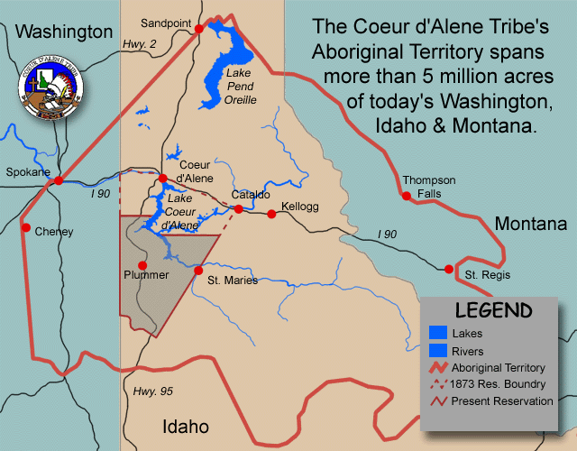
The Coeur d'Alene Tribe maintains 1:24:000 scale GIS data for its aboriginal
territory. This area stretches south to Moscow, Idaho, North to Sandpoint,
Idaho, West to Spokane, Washington and East to St. Regis, Montana.
The Tribal GIS program has worked hard to coordinate data collection with many
other organizations. When possible the Tribe has also entered into Memorandums
of Understanding with other organizations to foster GIS data sharing and
creation of new GIS data sets.
The Coeur d’Alene Tribe is using ArcGIS, ArcServer and ArcSDE to manage its GIS
data holdings. The Tribal GIS program has a variety of data scales it manages.
A majority of the data is natural resource grade GIS data, with a typical
accuracy of + or 40 feet.
If you are interested in acquiring data from the Coeur d'Alene Tribe you may
contact the GIS office at (208)686-2089, and download the License Agreement
from the link below. To complete the License Agreement you will need to have
Adobe Acrobat install on your computer. Once you complete the License Agreement
you can fax it to the GIS office at (208) 686-1901, and then mail the original
to the GIS office at PO Box 408, Plummer ID 83851. Some data sets will be placed
on our external web site for the licensee to download. Other data sets may need
to be burned to a DVD or CD because of file size, and then mailed to the licensee.
The Coeur d'Alene Tribe will evaluate each request for data on a case-by-case basis.
Link to Directions for GIS Data License
Agreement
Link to Data License
In addition the Tribe also has an ArcGIS Server and WMS services that can
be connected too via different GIS software. These services provide a live link
to a few of the Tribes datasets. The Tribe has both open service and password
protected services. For more information about these services please see the
link below.
Link to Directions for ArcGIS Server Live Services
|